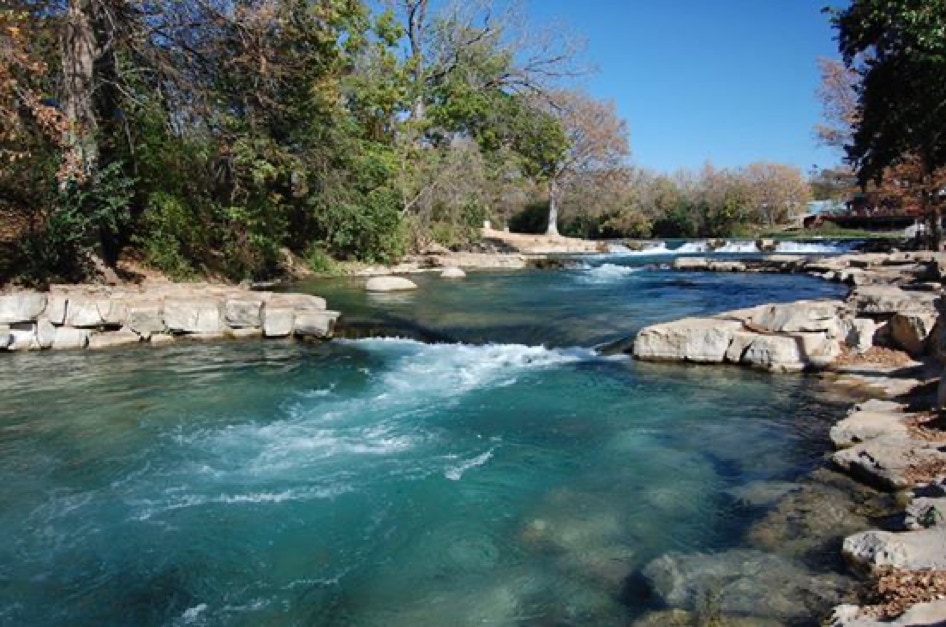
Rio Vista Falls, San Marcos
San Marcos River Trips
Known as the "River of the Innocents" to the Spanish Monks who "discovered" her, the San Marcos is one of the largest spring fed rivers in Texas. Average flow at the headwaters (known as the Aquarena Springs) is 130 cubic feet per second, and even during the driest of summers there has always been sufficient water for canoeing and other water sports. It is recognized as one of the most unique ecosystems in the world, with several endangered species living in its cool, 72 degree waters.
River Trip Distances and times:
Canoe or Kayak Trips
Canoe rentals are available from:
Paddle with Style 512-749-2350
Power Olympic Outdoor Center: 512-203-0093
Spencer Canoes in Martindale: 512-357-6113
Possible Trips Distance (miles) Average Time (hours)
City Park to San Marcos River Retreat 6 3
Thompson's Island to San Marcos River Retreat 4 2
San Marcos River Retreat to Scull's 4 2
San Marcos River Retreat to Martindale 6 3
Martindale to Staples 5 3
San Marcos River Retreat to Staples 11 6
Tube Trips
Tubes are available from the San Marcos Lion's Club at City Park. 512-396-5466.
Route Distance (miles) Average Time (hours)
City Park to Rio Vista Dam 1 1
County Rd. 101 to San Marcos River Retreat 1 1
Canoeing or Kayaking the San Marcos
The San Marcos is a great river for beginners because it has enough current to keep it interesting but rarely so much that it is dangerous. We always recommend that folks begin at City Park in San Marcos and end up at our camp. That is a six-mile trip and involves mostly flat water with just a few swift places. It generally takes about five to six hours which allows time for basic instruction and lunch. The most dangerous places on the river are the dams (three between San Marcos City Park and San Marcos River Retreat). Only the first, Rio Vista Falls, which is now a series of three rapids, is runnable (for whitewater boaters only)- the others should be portaged. As always, it is important to have someone along who is familiar with the river, and the group should be kept together to avoid misplacing someone.
If folks decide to continue downstream from our campground (and any section downstream of us should be for whitewater boaters only) they may choose from a trip to Sculls Crossing (4 miles); Martindale (6 miles); or Staples (11 miles). Downstream trips involve whitewater. One should always check on river conditions and/or have someone along who is familiar with the stretch of river being run. Talk to us if in doubt.
Tubing
The best tubing on the San Marcos River is the upper river (City Park to Rio Vista Rapids) and the section of river from our camp down to Sculls crossing.
The upper tubing stretch is approximately one mile long and takes about one hour. San Marcos Lion's Club operates a tube rental at City Park, as well as a shuttle service (they call it the river taxi service) by which they haul you back to City Park from Rio Vista Rapids.
If you choose to tube in the vicinity of our camp, there are several options. The easiest trip is to tube from one end of our camp to the other, which takes approximately thirty minutes. To do that, you merely carry your tube to site 20 where you launch, and then you float to site 8 where you take out. It is very important not to go past our gravel bar (between sites 8 and 9). Stop where the large “No stopping” sign is located (that sign is there to keep the tubers from Don’s and Texas State Tubes from stopping). If you go past our gravel bar you will either have to tube for about 4 hours down to Sculls Crossing or you will be trespassing when you get out of the river.
If you have your own tube(s) you might want to tube from CR 101/266 to our camp. That trip is less than a mile and takes less than an hour (the actual time depends on the flow of the river - if it is high and running fast it doesn’t take much time at all). Parking at CR 101/266 (aka Westerfield Crossing) is difficult; you have to park a good ways from the bridge and walk to the river. And, you will have to arrange your own shuttle.
If you want to tube a two mile stretch (2-3 hrs.), Starting at CR 101/266 and going past the campground, you can rent from Texas State Tubes located at the CR 101/266 bridge just upstream (there are also other outfitters available for that section). Arrive early at 10am weekends or 11am weekdays to beat the rush of rowdy tubers. There is also an earlybird discount of $10 per tube for the 1st hour. If you wait until noon to begin your trip you will be tubing with a lot of drunken college students. Start early.
If you choose to go downstream to Sculls Crossing (four miles-approximately 4 hours), you will have to move your pick up vehicle(s) downstream before your trip (be sure to ask us about parking at Sculls), or you will have to have someone meet you there. It is a long tube trip!
Under no circumstances should a person attempt to tube from the town of San Marcos to our camp. Cumming's Dam, located approximately 1.5 miles upstream from our camp causes a long lake - not difficult for a canoe to traverse, but too long and slow for a tube. Persons who have attempted to tube from town to Pecan Park have taken as long as twelve hours and were impossible to distinguish from white prunes once they got here.
Private Property
The land along the San Marcos River is privately owned. Stay in the river between your put-in and take-out points, and be sure you know the section of river your are running. When in doubt, ask us beforehand.
Canoeing the Upper San Marcos River
Mileage Guide to the San Marcos River (mileages are estimates only)
- By Tom Goynes
Launch at City Park in San Marcos. Be careful, the concrete can be very slippery.
¾ mile: Rio Vista Falls. Have everyone park their canoes on the left side above the falls. I usually have folks dock sideways and then I pull all the canoes out of the water to the far left and park them perpendicular to the wall (take up little space, leaving plenty of room for other groups to portage). Show the group the falls. The falls are man made rapids that were created to support an old dam. The first drop (the slot) is the hardest to run (especially for an open canoe). Most groups should portage (carry around) at least the first drop. It is possible portage the first drop and run the second and third (or to portage one and two and run # 3). If you decide to run the falls (or any part of it) only one canoe at a time should be on the water approaching the falls. Kneeling is very important here. Life Jackets essential. Station a person on the side of the first slot (be careful, the current is strong and the top of the dam is slimy) to show where the slot is and to assist with canoes that approach incorrectly. Station several guys below the falls to catch swamped boats (canoes have wrapped around the pilings of the bridge just downstream of the falls) and to direct traffic to the bank, and tie up and bail water out of the boats. Emphasize leaving the dam one canoe at a time, making sure the lead canoe has cleared the obstacles before the next canoe starts. Remember, it is OK to carry the canoes around the falls – and that is probably the best plan for most groups!
1 mile: IH 35
1.25 mile: Cape's Dam (beginning of Thompson's Island). Not a runnable dam (at least, not safe for open canoes). Portage this rock dam and go down the right channel around Thompson’s Island. First have everyone pull in on the tip of the island (there is some concrete there). Pull the canoes out as they arrive to make room for the next one. Portage to the calm water at the end of the concrete. As you go along, watch for a very large Bald Cypress tree on the left, very impressive. There will be some small rapids, so make sure that the group is alert and spaced out properly. As you approach Cape's road (a small bridge over the river) note that immediately upstream of the bridge on the left side, there is an old Sycamore stump that leans out over the channel. Canoes tend to be pulled into it sideways (I've seen lots of folks turn over at this point). Good place for them to learn the importance of reading the current. If you want to avoid the flips in the first place you should station a man above the tree to direct traffic to the right. Lots of current in this area. It is a hard place for novices to find a parking place - but that's life. Just downstream of the bridge there are some limbs to dodge and even a rock in the middle of the river! If you plan to eat lunch in this area (the island, downstream of the bridge, is state property - John Stokes Park) I would pick the first good parking place on the left that you can find (it will be right across from the discharge point for the state fish hatchery - some water coming into the river on the right side).
2.5 miles: The river will slow down. Lots of trees to dodge.
4.5 miles: Blanco River enters on the left. I would recommend waiting here for the stragglers to catch up (also make sure that no one beats you to this point). Once you have everyone together warn them to stay to the left as they approach Cumming's Dam.
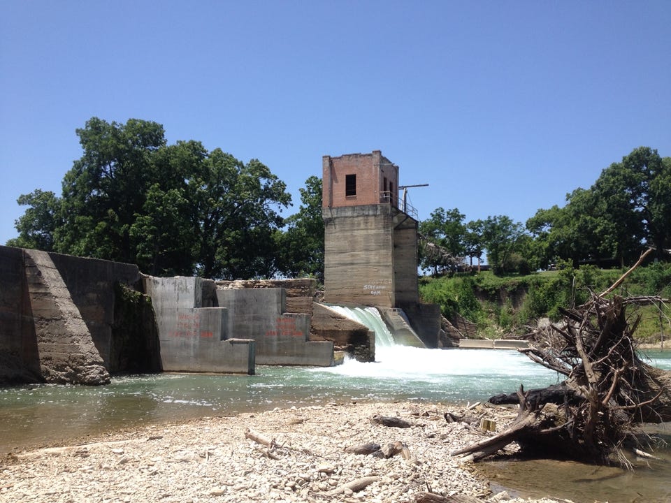
Cummings Dam
5 miles: Cumming's Dam (tower on left side). Very dangerous dam. Don't shoot it. Don't dive off it. Don't paddle back up toward the waterfall to "surf" - stay away from the hydraulic.
Currently the best portage trail is on the left side of the river starting very close to the dam. The land is private property so portage around the dam but don’t spend a lot of time there
5.5 miles: Westerfield Crossing - Portage on the right if the water is too high to get under the bridge.
6 miles: San Marcos River Retreat. Take out at the gravel bar (there is a sign that says “no stopping” - that sign is to keep the tubers from the tubing outfitters from taking over our gravel bar and making it impossible for you to have a place to stop). Please carry the canoes up the hill so the gravel bar will have enough room for the next group..
To run the river downstream of San Marcos River Retreat you will need to have your own canoe or kayak and you will have to acquire a guidebook or have someone along who knows the river. There be rapids there.